In one of the most densely populated regions of the world for its time, the ancient Maya experienced strong, centuries-old fluctuations in water and soil resources in their territory, induced by anthropisation and climate. For more than 2,500 years, the fluctuation, exploitation and management of these resources for agricultural purposes set the pace for the dynamics of Maya socio-ecosystems and contributed to their sustainability. This work, published in the journal Quaternary Sciences Reviews, was carried out by an interdisciplinary team of researchers from eight French laboratories.
During the ancient Anthropocene (from 2000 BC to 1000 AD) in Mesoamerica, socio-environmental interactions contributed to the rise and fall of the ancient Maya civilisation. At the scale of the territories in which the cities were exploited, the temporal variations in hydrological and sedimentary dynamics in response to anthropic and climatic controls are still poorly understood. This leads to a lack of knowledge about the dynamics of socio-ecosystems, and in particular water and soil resources, as well as the risks associated with their exploitation.
This study analyses and presents a regional comparison of the dynamics of a hydrosystem and a morpho-sedimentary system that were among the most transformed by the societies of the Maya Lowlands during the second half of the Holocene (the last 5,500 years). It focuses on the lacustrine basin of the El Infierno karstic depression and its watershed. These constituted the main water supply for the Maya city of Naachtun – a major regional capital between 150 and 950 AD – and which contains numerous remains of hydraulic and agricultural structures. The heart of the Maya Lowlands has not been occupied for around a millennium, since the decline of many cities during the Terminal Classic period. The study area is currently located in the Petén rainforest in Guatemala, where it is part of the Maya Biosphere Reserve.
An integrated palaeolimnological, geoarchaeological and hydrological approach was developed for this study. It is based on the analysis of sedimentary field archives, airborne LiDAR (Light Detection And Ranging) altimetry data and hydrological field data. It was used to construct hydrological and sedimentary reference frames for the periods before, during and after the ancient Maya occupations.
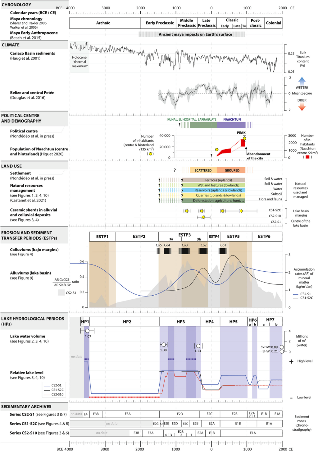
At present, the lake in the El Infierno karstic depression is intermittent and responds to strong seasonal and interannual hydrological variability, under climatic control. Over the last 5,500 years, its hydro-sedimentary fluctuations have been marked by the alternation of seven main hydrological periods, characterised by high and low lake levels (lake alternately perennial, intermittent and dry) and six main periods of erosion and sediment transfer, marked by high and low sediment inputs (the ‘Mayan clays’). Anthropisation and climate have independently and sometimes jointly controlled these fluctuations, which represented constraints and opportunities for the ancient Maya. For example, as early as 1500 BC, the clearing of forests for agricultural purposes by the Maya helped to increase the water resources of the land, by modifying the hydrological balances of the catchment areas. Later (between ∼1500 BC and ∼1150 AD), the deposition of ‘Maya clays’ in karst depressions in response to anthropogenic soil erosion irreversibly transformed the lakes and wetlands of the territories. As a result, lake levels were lowered and soils developed on former lake shores became agricultural areas where maize was grown. Finally, around 1000 AD, an episode of low lake levels, which occurred in response to a period of drought, reduced agricultural yields during the city’s demographic heyday. These dynamics may have increased the socio-environmental, economic and political tensions in the socio-ecosystem, shortly before and during its final decline.
This study reveals one of the longest periods of occupation and exploitation of natural resources in the Maya Lowlands (BTM), spanning more than 2,500 years during the Preclassic, Classic and Postclassic Maya periods. It appears that the hydro-sedimentary dynamics at play in the many karstic depressions of the BTM enabled the long-term exploitation of water and soil resources for agrarian purposes, thanks to the construction of palimpsest, hydraulic and agrarian landscapes, shaped by Maya socio-ecosystems.
This study provides integrated information and analysis of four main ‘Golden Spikes’ considered for the Early Maya Anthropocene. Present in the stratigraphy of sedimentary records, they mark the anthropic transformation of the biophysical environments of the BTM, on a large scale and from the Preclassic period onwards. These include ‘Mayan clays’, anthropised palaeosols, carbon isotope ratios in anthropised soil-sedimentary sequences and LiDAR-derived indicators of human activity (qualitative and quantitative variables) still present in the landscape today (housing, agricultural terraces, raised and drained fields).
From now on, knowledge of past hydro-sedimentary fluctuations will make it possible to study their agronomic and economic implications for the dynamics and sustainability of past socio-ecosystems, as well as their implications for the environmental dynamics currently at play in the Maya Biosphere Reserve.
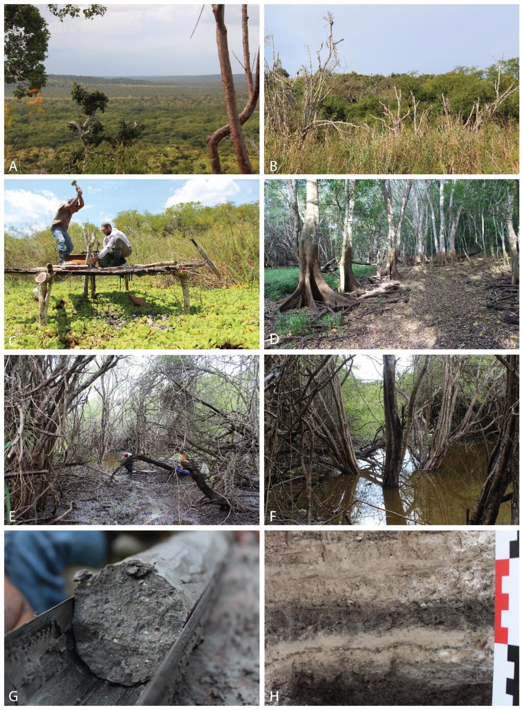
Present-day biophysical environments of the El Infierno lake depression and wetland, located next to the town of Naachtun in the Maya Biosphere Reserve in Guatemala (photos A to F). Sedimentary archives of past environmental and socio-environmental dynamics and their collection (photos C, E, G and H). Credits: Cyril Castanet.
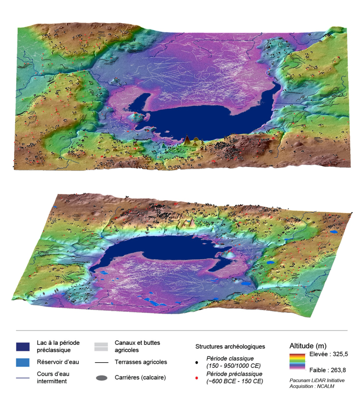
Reconstruction of the ancient lake and the palimpsest, hydraulic and agrarian landscapes shaped by the Maya socio-ecosystems around the centre of the city of Naachtun, between ∼1500 BC and ∼1150 AD. Top: View from the centre of the city towards the lacustrine depression to the north. Bottom : View from the lacustrine depression towards the city. Model area: ~10 km². Credits: Cyril Castanet, Naachtun Project.
CNRS laboratories involved
- Laboratoire de Géographie Physique : Environnements Quaternaires et Actuels (LGP – CNRS / Université Panthéon Sorbonne / Université Paris-Est Créteil Val-de-Marne)
- Cultures et Environnements. Préhistoire, Antiquité, Moyen Âge (CEPAM – CNRS / Université Côte d’Azur)
- Environnement Dynamique et Territoires de la Montagne (EDYTEM – CNRS / Université Savoie Mont Blanc)
- Laboratoire des Sciences du Climat et de l’Environnement (LSCE – CNRS / CEA / Université Versailles Saint-Quentin-en-Yvelines)
- Archéologie des Ameriques (ARCHAM – CNRS / Université Panthéon-Sorbonne)
- Archéosciences-Bordeaux : Matériaux, temps, Images et Sociétés (Archéosciences-Bordeaux – CNRS / Université Bordeaux Montaigne)
- Géosciences Rennes (CNRS / Université Rennes 1)
Sustainable development objectives

- Objective 13: Combating climate change
In particular, this research is helping to achieve the sub-objective ‘Combating all climate risks’, by increasing our knowledge of the response of current and past tropical biophysical environments to climate change and our knowledge of the response of ancient Mayan socio-ecosystems to climate change.
Reference
CASTANET C., PURDUE L., TESTE M., GARNIER A., DEVELLE-VINCENT A.-L., MOKADEM F., HATTE C., GAUTHIER C., LANOS P., DUFRESNE P., LEMONNIER E., DUSSOL L., HIQUET J., NONDEDEO P., 2022. Multi-millennial human impacts and climate change during the Maya early Anthropocene : implications on hydro-sedimentary dynamics and socio-environmental trajectories (Naachtun, Guatemala). Quaternary Science Reviews
Contacts