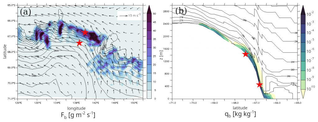
Recent regional model findings suggest that the aeolian erosion of surface snow is a significant contribution to the overall Antarctic surface mass balance (SMB) through ice crystals sublimation and export outside of the ice sheet. Such findings raise the question of the relevance of accounting for such a process also in global climate models. This study presents the development of an intermediate-complexity parameterisation of blowing snow for the ICOLMDZ atmospheric general circulation model, the atmospheric component of the IPSL Coupled Model. The parameterisation is designed to be a trade-off between physical complexity and applicability in a general circulation model, with constraints on numerical cost and stability. The parameterisation is evaluated with in situ observations using limited-area simulations over Adélie Land. The model exhibits satisfactory results in terms of summer wind speed, temperature and intensity of blowing snow fluxes. In winter, blowing snow intensity and occurrences are overestimated close to the coast, concurring with a positive wind speed bias. In terms of blowing snow occurrences throughout the year, ICOLMDZ exhibits comparable performance with the regional atmospheric model MAR. Boundary-layer moistening and cooling as well as changes in surface radiative fluxes due to blowing snow crystals are also quantified in the simulations.
Global simulations at standard global climate model resolution are carried out to investigate how the Antarctic SMB is modified with the activation of the blowing snow parameterisation. Results show an overall decrease of the net snow accumulation in the escarpment region due to surface snow erosion and an increase along the coast due to blowing snow deposition and increase in precipitation.
Authors: Vignon, É., Chiabrando, N., Agosta, C., Amory, C., Wiener, V., Charrel, J., Dubos, T., Genthon, C.
Geosci. Model Dev., 19, 239–259, https://doi.org/10.5194/gmd-19-239-2026, 2026