ICOS-RAMCES team (atmospheric network for greenhouse gaz compounds measurement) coordinates the National Greenhouse Gas Observation Service, which is the French component of the European ICOS (Integrated Carbon Observation System) network for the atmosphere. The SNO provides continuous, high-precision measurements of atmospheric concentrations of greenhouse gases (CO2, CH4, N2O) and the team’s scientists interpret changes and variations in these gases over time (from seasonal, annual to multi-decadal scales) and space (from global and/or national scales, down to city and local sources of emissions of these gases).
ICOS-France-Atmosphere monitoring network
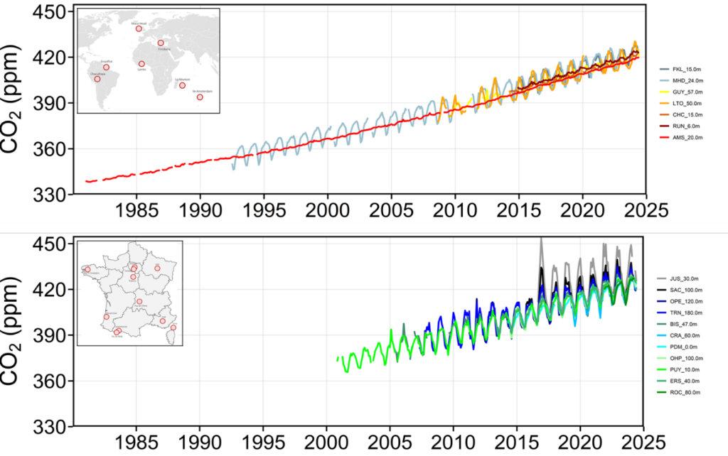
SNO-ICOS-France-Atmosphere is one of the largest GHG measurement networks in Europe, and as such makes an essential contribution to determining GHG balances on the European continent. It is the French component of the observation network of the European research infrastructure IR* ICOS-ERIC. The SNO ICOS-France-Atmosphere currently comprises 18 stations: 11 in mainland France, 2 in Europe (Ireland (Mace Head) and Greece (Finokalia)), 4 in the tropics, and the historic station on Amsterdam Island in the Indian Ocean, where CO2 has been measured since 1980. The measurements of greenhouse gas concentrations (CO2, CH4, N2O) developed within SNO-ICOS-France-Atmosphere, according to the protocols of the ICOS infrastructure, are in-situ measurements in the boundary layer directly linked to the standards of the World Meteorological Organisation. These extremely accurate (~0.05%) continuous measurements are essential for long-term monitoring of GHG trends in the atmosphere, and their inter-annual and seasonal variability associated with specific climatic events affecting natural fluxes (e.g. drought, fires, etc.), or crises affecting anthropogenic emissions (e.g. COVID confinements, Nord-Stream gas leak, etc.).
The aim of long-term monitoring of atmospheric concentrations of greenhouse gases (GHGs) is to understand the natural cycles of these gases, disrupted by human activities, which are the primary cause of global warming. The main greenhouse gases CO2, CH4 and N2O have anthropogenic emissions linked to the extraction and combustion of fossil fuels, as well as to the agricultural sector, which are superimposed on natural sources and/or sinks. Understanding and assessing the radiative forcing of these gases requires knowledge of the balances of their sources and sinks across the globe on a regional scale, and on monthly to decadal time scales. The challenge for a network of atmospheric measurements is to have a sufficiently dense and accurate grid of the atmosphere to deduce CO2, CH4 and N2O fluxes on a spatial scale that makes it possible to differentiate between anthropogenic, biospheric and oceanic contributions. This is currently only possible with ground networks in certain regions of the world, including Europe, where the number of stations is sufficiently dense. For regions where it is not possible to densify the ground network (oceans, tropical zones), satellites can in principle provide global coverage; however, their measurements are limited to cloud-free situations, and the calibration and/or validation of these data remains a subject of research, based on remote sensing data.
Integrated measurements
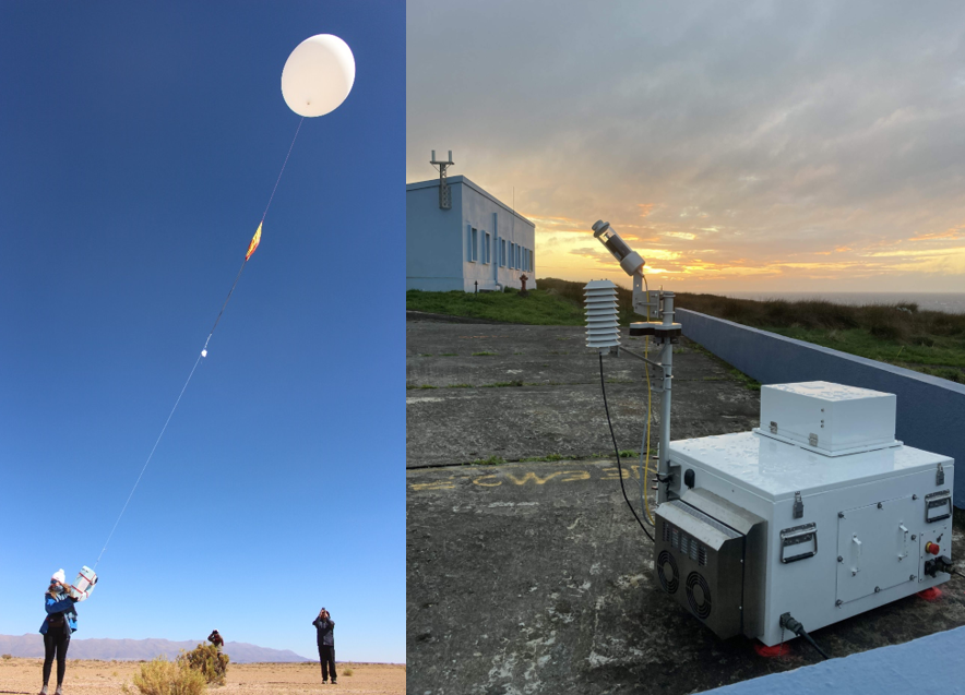
To compensate for the lack of observation on the ground (over the oceans, in areas that are not very accessible or not very densely instrumented), scientists have developed new observation or sampling techniques based on integrated measurements of the air column by satellite from space or from the ground (Lidar), or by stratospheric sounding balloon (AirCore, which can reach an altitude of over 30 km). These measurements are complementary to each other (they enable the different types of measurements to be validated, particularly those from satellites) and to measurements from the surface network. They also provide a better understanding of atmospheric dynamics and document atmospheric gradients. ICOS-RAMCES team has been involved in this new type of measurement for several years. It deploys a Lidar network (EM27) at several of its ground stations (such as the Amsterdam Island site opposite) and regularly releases AirCore from the Trainou site in the Loiret region of France.
Measurements in urban environments
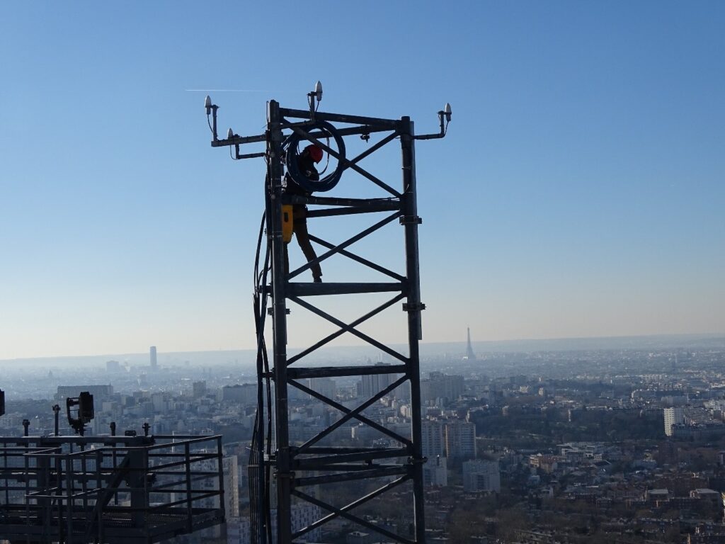
Cities are home to an ever-increasing proportion of the world’s population. They account for almost 75% of global CO2 emissions and have therefore become a major challenge for greenhouse gas monitoring. In order to measure greenhouse gases in urban environments, it is necessary to adapt to local conditions, such as high signal variability, diversified local emission sources and a high baseline level. This often means adapting the observation network, with a greater number of measurement points (but also greater flexibility in terms of measurement accuracy). ICOS-RAMCES team is involved in the European ICOS-Cities project, of which Paris is one of the 3 pilot cities (along with Munich and Zurich). It has deployed a GHG monitoring network in and around Paris comprising 10 high-precision observation sites and around thirty medium-precision sites deployed on the roofs of Paris.