ESTIMR > Dépêches > Adjusting spatial dependence of climate model outputs with cycle-consistent adversarial networks
Adjusting spatial dependence of climate model outputs with cycle-consistent adversarial networks
Climate simulations have spatial biases, i.e., spatial properties (e.g., rainfall variability between different sites) can differ from observations. Consequently, corrections of spatial properties are needed, e.g. for impact studies [1]. As proof-of-concept, we proposed to adapt a computer vision technique used for Image-to-Image translation tasks (named CycleGAN [2]) for the adjustment of spatial properties of climate simulations [3].
The proposed algorithm, named MBC-CycleGAN, consists in learning to transfer simulated maps (seen as images) from climate simulations with inappropriate spatial properties to more realistic images with spatial properties similar to the observed ones. We tested MBC-CycleGAN by performing two bias correction exercises, both with respect to SAFRAN references [4] for temperature and precipitation data over the region of Paris:
Bias correction of climate simulations IPSL -> SAFRAN (IPSL data do not temporally match SAFRAN data).
Downscaling of « low-resolution » SAFRAN -> SAFRAN (LR SAFRAN data temporally match SAFRAN).
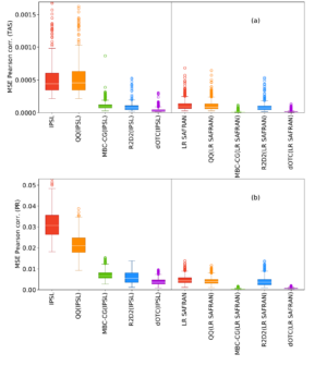
We compared the results for the correction of the spatial properties with other state-of-the-art bias correction methods (Quantile-quantile [5], R2D2 [6] and dOTC [7]). MBC-CycleGAN produced reasonable adjustments of spatial correlations for temperature and precipitation compared to the other alternatives. In particular, better results are obtained for the correction of paired images (« low-resolution » SAFRAN).
These results suggest that CycleGAN is very promising for multivariate bias correction. Of course, further research is needed, such as extending our method to correct not only spatial properties but also inter-variable and/or temporal ones.
Figure: These panels show boxplots of mean squared errors (with respect to SAFRAN reanalysis data) of spatial correlations computed at each grid cell for (a) temperature and (b) precipitation.
Results are presented for IPSL, « low resolution » SAFRAN and the results from MBC-CycleGAN
(in green) and 3 other bias correction methods. The closer the boxplots are to zero, the more the spatial properties are in line with those from SAFRAN. See [3] for further details.