
Faits marquants 2018
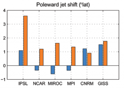
La circulation atmosphérique des moyennes latitudes conditionne une partie du climat européen et des moyennes et hautes latitudes de l’hémisphère Sud, où elle est également un élément important pour les échanges océan-atmosphère en CO2. Au cours des cinq dernières années, nous avons examiné les éléments responsables du changement de cette circulation d’ouest dans l’hémisphère sud et dans le secteur Atlantique Nord – Europe pour le climat du Dernier Maximum Glaciaire (DMG) par rapport à l’actuel. Dans l’article de Chavaillaz et al. (2013) nous montrons (Figure 1) que malgré un forçage radiatif équivalent entre les états DMG et Pré-industriel d’une part, et entre Pré-industriel et RCP4.5 d’autre part, les résultats sont différents pour les deux changements : pour le futur, les modèles simulent systématiquement un décalage du courant-jet vers le pôle, alors que pour le passé la moitié seulement des modèles simulent un tel décalage, les autres simulant un décalage vers l’équateur. Nous avons montré que ces modèles étaient plus sensibles que les autres aux changements d’altitude de la calotte Antarctique imposée dans le protocole DMG, montrant ainsi la potentielle importance des changements de topographie.
Si les dynamiques de l’océan et de l’atmosphère peuvent être représentées par des modèles physiques explicites comme les GCMs, ce n’est plus le cas lorsqu’il s’agit de l’évolution à long terme des calottes de glaces ou bien du cycle du carbone, notamment en réponse aux forçages astronomiques. Afin de construire une théorie de ces variations, nous avons formalisé les principaux mécanismes sous forme d’un modèle conceptuel.
L’évolution couplée climat-carbone lors des cycles glaciaire-interglaciaire peut sans doute s’expliquer via les processus de formations d’eaux de fond Antarctiques (Paillard, 2015 ; Mariotti et al. 2016). Cependant, l’existence de cycles à 400 000 ans dans les enregistrements de 13C cycles n’est pas spécifique du Quaternaire (eg. Paillard & Donnadieu, 2014). Sur le Plio-Pléistocène, la modulation d’amplitude de l’excentricité à 2-2,4 millions d’années permet d’expliquer simplement, à travers un modèle conceptuel, non seulement l’allure des cycles du 13C, mais aussi, de façon conjointe, une modulation du carbone total sur Terre avec une première chute du CO2 atmosphérique vers 2,7 Ma BP (début du Pléistocène et des cycles à 41 ka), puis une deuxième chute vers 0.7 Ma BP (Mid-Pleistocene transition, début des cycles à 100ka).
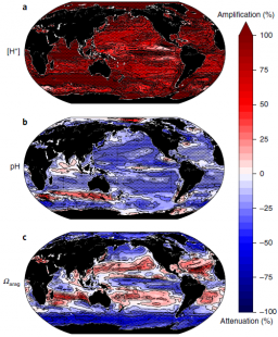
Cette étude montre que si le CO2 atmosphérique continue d'augmenter, les différences entre été et hiver des extrêmes d'acidité des océans doubleront d'ici à la fin du siècle. Elle met donc en doute l'idée que les régions présentant actuellement une forte variabilité entre saisons pourraient offrir à leurs organismes marins une certaine résistance aux changements des conditions moyennes plus lents mais progressifs, tels que ceux provoqués par l'acidification des océans.
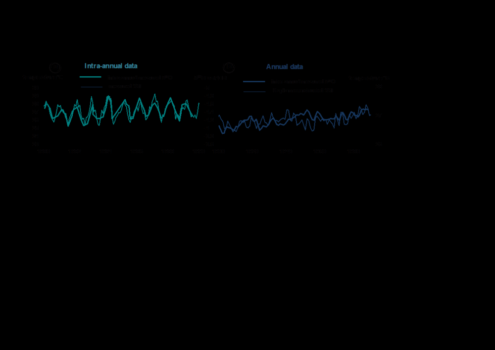
L’augmentation de la différence d’acidité entre été et hiver devrait se produire dans toutes les régions océaniques (Figure 1, en haut). Dans les régions tropicales et subtropicales, l’impact de cet accroissement sur les organismes risque alors de s'aggraver en été lorsque l'acidité est la plus élevée et de s'améliorer en hiver lorsque l'acidité est la plus faible.
Les projections futures de ces extrêmes saisonniers proviennent de neuf modèles CMIP5. Les études antérieures des changements futurs de l'acidification des océans ont principalement porté sur les conditions moyennes annuelles et ne tiennent pas compte des changements des extrêmes d'hiver et d'été.
L’étude a aussi comparé les projections futures des variations saisonnières de l’acidité aux changements potentiels de la variabilité quotidienne en utilisant des mesures continues de pH recueillies sur deux sites voisins dans la baie de Naples. Un site a servi de référence actuelle, tandis que l'autre montrait les niveaux d'acidité et de CO2 attendus pour la fin du siècle, étant affectés par le CO2 volcanique bouillonnant naturellement depuis le fond marin. La différence jour-nuit de l'acidité au site perturbé était d’environ le double de celle du site de référence, ce qui concorde avec les résultats des projections du modèle pour l'amplification saisonnière.
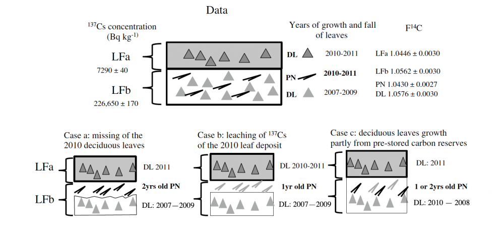
Radiocarbon and radiocesium were measured on litter fractions (LF) collected on November 19th, 2011 at 40 km NW of the FDNPP. The 137Cs concentration is much higher in the lower fraction LFb at 226,650 ± 170 Bq kg−1 than in the upper fraction LFa at 7290 ± 40 Bq kg−1. From leaf-air 14C comparison, no excess 14C due to the FDNPP accident is detected in LFa deposited in 2010–2011. A significant 14C difference of 1.4% exists between pine needles and deciduous leaves in LFb, which may be due either to post-depositional processes or to a turnover time of 0.5–1 year of stored carbon for deciduous leaves growth.
Référence : Paterne M., Evrard O., Hatté C., Laceby P.J., Nouet J., Onda Y., 2019. Radiocarbon and radiocesium in litter fall at Kawamata, ~45 km NW from the Fukushima Dai-ichi nuclear power plant (Japan). Journal of Radioanalytical and Nuclear Chemistry 319, 1093-1101. Doi:10.1017/s10967-018-6360-9
La circulation atmosphérique des moyennes latitudes conditionne une partie du climat européen et des moyennes et hautes latitudes de l’hémisphère Sud, où elle est également un élément important pour les échanges océan-atmosphère en CO2. Au cours des cinq dernières années, nous avons examiné les éléments responsables du changement de cette circulation d’ouest dans l’hémisphère sud et dans le secteur Atlantique Nord – Europe pour le climat du Dernier Maximum Glaciaire (DMG) par rapport à l’actuel. Dans l’article de Chavaillaz et al. (2013) nous montrons (Figure 1) que malgré un forçage radiatif équivalent entre les états DMG et Pré-industriel d’une part, et entre Pré-industriel et RCP4.5 d’autre part, les résultats sont différents pour les deux changements : pour le futur, les modèles simulent systématiquement un décalage du courant-jet vers le pôle, alors que pour le passé la moitié seulement des modèles simulent un tel décalage, les autres simulant un décalage vers l’équateur. Nous avons montré que ces modèles étaient plus sensibles que les autres aux changements d’altitude de la calotte Antarctique imposée dans le protocole DMG, montrant ainsi la potentielle importance des changements de topographie.

TARA-Pacific, qui a débuté le 28 mai 2016, s’est terminé le Samedi 27 Octobre 2018 après 2 ans et demi de navigation avec le retour médiatique de TARA à Lorient. Cette expédition, coordonnée par Serges Planes (CNRS), Denis Allemand (CSM) et Romain Troublé (TARA), a pour motivation générale d’étudier la biodiversité des récifs coralliens actuels et passés sur l'intégralité de l'océan Pacifique par une approche « transversale » impliquant des experts de différents horizons scientifiques. Les chercheurs souhaitent en particulier faire un bilan de l'état de santé actuel des récifs tropicaux et évaluer leur capacité de résilience et d’adaptation face aux changements globaux dus à l’ère industrielle. Pour réaliser ces études d’impact, le Centre Scientifique de Monaco (CSM) en étroite collaboration avec le LSCE, ont organisé à bord du TARA le prélèvement par forage de nombreuses carottes de corail. Le bilan est aujourd’hui extrêmement positif puisque 35 carottes de corail couvrant les 2 derniers siècles ont été prélevées sur 32 îles ou atolls de l’océan Pacifique. Dans le cadre d’une convention CSM-CEA qui sera signée en décembre 2018 pour la période (2018-2022), nous proposons de valoriser ces prélèvements et donc de reconstruire à l’échelle annuelle, voire saisonnière, l’évolution historique de la température et du pH-DIC (cycle du carbone) de l’océan Pacifique et de comparer les données géochimiques obtenues avec celles liées aux propriétés de croissance des colonies de corail Porites et Diploastrea prélevées.
https://www.france.tv/france-2/telematin/805937-environs-des-excursions-scientifiques-pour-sauver-les-coraux.html
Ce travail implique à la fois des analyses géochimiques de pointe (d11B et B/Ca pour le pH, les éléments traces et les rapports Li/Mg et Sr/ca pour la température, certains métaux lourds ou polluants pouvant également affecté la santé des coraux et les isotopes stables du C et de l'O pour tenir compte de la bio-minéralisation ou de l’effet Suess. Ces analyses seront logiquement réalisées sur les spectromètres de masse de nouvelle génération du LSCE (ICP-QMS, MC-ICPMS et IRMS). Ces travaux seront accompagnés d’une analyse qualitative (DRX/MEB) et d’une analyse de la densité (Tomographie/Radiographie-X) permettant le comptage des bandes annuelles (modèle de croissance des coraux tropicaux) et l’établissement des paramètres de croissance (densité, extension linéaire, taux de calcification).
Ces travaux autour des éléments traces (B/Ca, Li/Mg, Sr/Ca, etc.) et des isotopes du B nous permettront de reconstruire l’évolution historique de la température et de la chimie des carbonates pour l’océan Pacifique. Et ces données géochimiques, comparées à celles physiologiques, apporteront des informations uniques sur la résilience des coraux face aux changements globaux.
Fin de l’expédition TARA-Pacific (Mai 2016 – Octobre 2018), France 2 (Télématin 09.11.18)
Coll. CSM & TARA consortium ; projet LSCE-LOV-MIO-CSM PACIFIC-Impacts soumis à l’ANR
Recent findings suggest that soil organic carbon mineralization and stabilization depend to a substantial degree on the soil geochemistry and the degree of weathering. We hypothesized that this dependence can be translated to decay rate modifiers in a model context, and used data from the Merced chronosequence (CA, U.S.A., 100 yr – 3 Myr), representing a weathering sequence, to test, on a 1000-year time scale for model spin-up, a simple soil organic carbon (SOC) model based on the RothC26.3 model concepts. Model performance was tested for four levels of information: (1) known decay rates for each model SOC pool at individual chronosequence locations, obtained by calibrating the model to measured SOC-fractions and measured site-specific C-inputs; (2) average decay rates for each SOC-pool, corrected per location with rate modifiers based on geochemical proxies and measured site-specific C-inputs; (3) uncorrected average decay rates per SOC-pool and measured site-specific C-inputs; (4) uncorrected average decay rates per SOC-pool and averaged C-inputs. A lumped root mean square error (RMSE) statistic was calculated for each information level. We found that using local measurements of fresh C-input led to a decrease in RMSE of near 15% relative to information level (4). Applying geochemical rate modifiers led to a further reduction of 20%. Thus, we conclude that there is a benefit of including geochemical rate modifiers in this SOC-model. We repeated this analysis for a five-pool and a four-pool SOC model that either included or excluded an inert organic matter pool. In terms of the lumped RMSE both models performed similarly, but by comparing measured and simulated percentage Modern Carbon (pMC) for bulk SOC we concluded that measured pMC was best approximated using a four-pool SOC model (without an Inert Organic Matter pool). Furthermore, it is likely that a five-pool model including a very slowly decaying pool would further improve model performance.
Référence : Finke P., Opolot E., Balesdent J., Behre A. A., Boeckxx P., Cornu S., Harden J., Hatté C., Williams E., Doetterl S., 2019. Can SOC modelling be improved by accounting for pedogenesis? Geoderma 338, 513-524. Doi: 10.1016/j.geoderma.2018.10.018

Light, an environmental parameter playing a crucial role in coral aragonite growth and d18O formulation, is always neglected in the geochemical literature. However, by revisiting already published studies, we demonstrated that light might be considered as a vital effect affecting coral aragonite oxygen isotopic ratios. Re-examining data series included in a publication by Weber and Woodhead (1972), we stressed that annual d18O–annual temperature calibrations of all considered coral genera may be compared because their assessment assumes homogenous light levels. Temperature prevails on d18O because it influences d18O in two ways: firstly it acts as is thermodynamically predicted implying a d18O decrease; and secondly it induces an enhancement of photosynthesis causing d18O increase. When the highest annual temperature occurs simultaneously with the highest annual irradiation, the annual d18O amplitude is shortened. The annual d18O–annual temperature calibration is also explained by the relative distribution of microstructures, centres of calcification or COC and fibers, according to morphology, and in turn taxonomy. We also investigated monthly d18O–monthly temperature calibrations of Porites grown at the same sites as by Stephans and Quinn (2002), Linsley et al. (1999, 2000) and Maier et al. (2004). Multiple evidence showed that temperature is the prevailing environment forcing on d18O and that the mixture of temperature and light also determines the relative distribution of microstructures, explaining the relationships between Porites calibration constants. By examining monthly and annual d18O–monthly and annual temperature calibrations, we revealed that monthly calibration results from the superimposition of seasonal and annual variability over time. Seasonal d18O strongly impacted by seasonal light fluctuations, may be obtained by removing interannual d18O only weakly affected by light. Such features necessitate the reconstitution of tools frequently utilised, such as the coupled d18O – Sr/Ca or pseudo-coral concepts.
Référence : Juillet-Leclerc A., 2018. The role of light as vital effect on coral skeleton oxygen isotopic ratio. Biogeoscience Discussion. Doi: 10.5194/bg-2018-433
The Harletz loess-palaeosol sequence is located in northwestern Bulgaria and represents an important link between well studied loess sequences in eastern Romania and further sites to the west of the Carpathians (e.g. Serbia and Hungary).
The aim of this study was to establish a chronostratigraphy of the deposits, using various methods of luminescence dating, together with basic stratigraphical field observations as well as magnetic properties. Luminescence dating was carried out using the quartz fine grain fraction and a SAR protocol, and the feldspar coarse grain fraction, applying the MET-pIRIR protocol. Due to underestimation of the quartz fine grain fraction in the lower parts of the sequence, the resulting chronology is mainly based on the feldspar ages, which are derived from the stimulation temperature at 150 °C. A comparison with nearby sequences from Serbia, Hungary and Romania, and interpretations obtained through the stratigraphical and sedimentological signature of the sequence, supports the established chronology. Our data suggest that the prominent palaeosol (soil complex) in the upper quarter of the sequence was formed during MIS 5. It would follow that large parts of the Last Glacial loess overlying this palaeosol were probably eroded, and that the thick loess accumulation underlying this soil complex can be allocated to the penultimate glacial (MIS 6). A prominent MIS 6 tephra, which has been reported from other sequences in the area, is also present at Harletz.
Lomax J., Fuchs M., Antoine P., Rousseau D.-D., Lagroix F., Hatté C., Taylor S.N., Till J.I., Debret M., Moine O., Jordanova D., 2018. A luminescence-based chronology for the Harletz loess sequence, Bulgaria. Boreas 48, 179-194. doi : 10.111/bor.12348
Etude financée par l'ANR ACTES
River management is generally thought to have started at 5500 cal. BC within the development of eastern Neolithic societies. In the Lesser Caucasus, evidence of early river management has been discovered around the famous Neolithic sites of Shulaveri, Gadachrili Gora, and Imiris Gora in Georgia. Here we report a preliminary data set indicating that river management was set up at 5900 cal. BC leading to the flooding, destruction, and local abandonment of the hydraulic infrastructures of the Gadachrili village between 5750 and 5430 cal. BC. The hydraulic infrastructures were developed during a more humid period encompassing the 8200 cal. BP (6200 cal. BC) climatic event, probably to optimize agricultural yield. It potentially led to the first prehistoric engineering accident for which there is evidence, which may have been followed by the reorganization of the occupation and/or to architectural modifications.
Référence : Ollivier V ., Fontugne M., Hamon C., Decaix A., Hatté C., Jalabadze M., 2018. Neolithic water management and flooding in the lesser Caucasus (Geogia). Quaternary Science Reviews 197, 267-287. Doi: 10.1016/j.quascirev.2018.08.016
Etude financée par l'ANR KURA
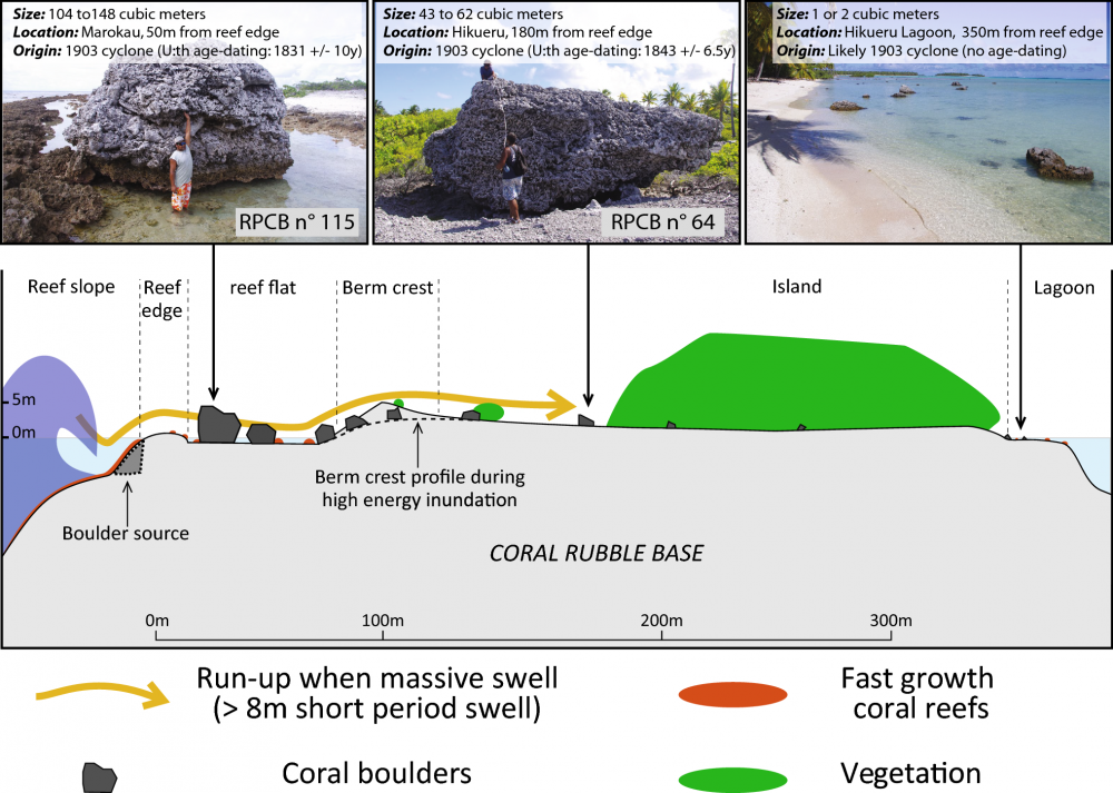
On intertropical coastlines, coral boulders located on the reef platform are often used to characterize high-energy marine inundations of the past. Precise U/Th coral dating provides opportunities to assess the timing and recurrence of these events. However, this method of dating is subject to several limitations, as revealed by studying live coral cover at five islands in French Polynesia, since the early 1990s. We show that live coral assemblages experience very different changes within the islands of the same archipelago. Moreover, our observations show that the passage of a cyclone causes almost complete disappearance of the most recent coral in the coral boulder formation zone. This analysis shows that the probability of taking coral samples that were alive on the day of the high-energy marine inundation is extremely low. We have clarified the limitations of this method based on the dating of coral assumed to be alive on the day of the well-documented high-energy marine inundation of 1903 AD. The dating of 24 samples taken from 22 boulders from 3 islands of the Tuamotu Archipelago shows that important parts of the coral were dead when displaced by the marine inundations, thereby overestimating the timing of the disturbance event. As such, U/Th coral dating has limited application for establishing the precise timing for high-energy marine inundations with a return period of less than a century, but may be useful for exploring infrequent and extreme events such as the cyclone that ravaged the Tuamotu atolls in 1903. Indeed, we observed that this cyclone is the one that produced the world’s largest reef-platform coral boulders (more than 100 m3). We also provide evidence of an earlier event in the center of the Tuamotu Archipelago, during the middle of the first century AD.
Référence : Canavesio R., Pons-Branchu E., Yannick C., 2018. Limitations to U/Th dating of reef-platform carbonate boulders produced by high-energy marine inundations in the Tuamotu Archipelago (French Polynesia). Coral reefs 37, 1139-1155. Doi: 10.1007/s00338-018-1732-8
Despite the societal importance of extreme hydroclimate events, few palaeoenvironmental studies of Scandinavian lake sediments have investigated flood occurrences. Here we present a flood history based on lithological, geochemical and mineral magnetic records of a Holocene sediment sequence collected from contourite drift deposits in Lake Storsjön (63.12° N, 14.37° E). After the last deglaciation, the lake began to form around 9800 cal yr BP, but glacial activity persisted in the catchment for ~250 years. Element concentrations and mineral magnetic properties of the sediments indicate relatively stable sedimentation conditions during the Holocene. However, human impact in the form of expanding agriculture is evident from about 1100 cal yr BP, and intensified in the 20th century. Black layers containing iron sulphide appear irregularly throughout the sequence.
The exchange of carbon between soil organic carbon (SOC) and the atmosphere affects the climate and—because of the importance of organic matter to soil fertility—agricultural productivity. The dynamics of topsoil carbon has been relatively well quantified, but half of the soil carbon is located in deeper soil layers (below 30 centimetres), and many questions remain regarding the exchange of this deep carbon with the atmosphere8. This knowledge gap restricts soil carbon management policies and limits global carbon models. Here we quantify the recent incorporation of atmosphere-derived carbon atoms into whole-soil profiles, through a meta-analysis of changes in stable carbon isotope signatures at 112 grassland, forest and cropland sites, across different climatic zones, from 1965 to 2015. We find, in agreement with previous work, that soil at a depth of 30–100 centimetres beneath the surface (the subsoil) contains on average 47 per cent of the topmost metre’s SOC stocks. However, we show that this subsoil accounts for just 19 per cent of the SOC that has been recently incorporated (within the past 50 years) into the topmost metre. Globally, the median depth of recent carbon incorporation into mineral soil is 10 centimetres.
Variations in the relative allocation of carbon to deep soil layers are better explained by the aridity index than by mean annual temperature. Land use for crops reduces the incorporation of carbon into the soil surface layer, but not into deeper layers. Our results suggest that SOC dynamics and its responses to climatic control or land use are strongly dependent on soil depth. We propose that using multilayer soil modules in global carbon models, tested with our data, could help to improve our understanding of soil–atmosphere carbon exchange.
Références : Balesdent J., Basile-Doelsch I., Chadoeuf J., Cornu S., Derrien D., Fekiacova Z., Hatté C., 2018. Atmosphere-soil carbon transfer as a function of soil depth. Nature, 559, 599-602. doi:10.1038/s41586-018-0328-3
Etude financée par les projets ANR DEDYCAS et LEFE DYVERTIS
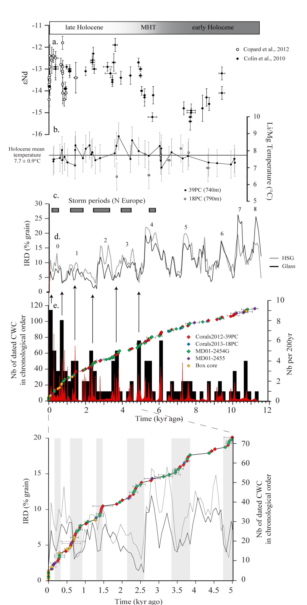
U-Th ages and temperatures derived from Li/Mg have been measured on coral fragments of L. pertusa and M. oculata collected from sediment cores, which were taken from cold-water coral (CWC) mounds at 700-790 m water depth at the SW Rockall Trough margin. Data from this study combined with previous ones from other cores collected in the same mound region allowed us to not only estimate the occurrence of CWC at the SW Rockall Trough margin during the Holocene, but also to constrain the environmental conditions driving variability in CWC growth. CWC abundance is marked by a pronounced increase in the mid-Holocene (~6 ka) and is modulated by millennial-scale variability throughout the late Holocene. The mid-Holocene proliferation of CWC coincide with lowest IRD abundances and a major re-organization of the circulation at thermocline depth in the Rockall Trough, marked by the progressive replacement of the fresh-cold SubArctic Intermediate Water (SAIW) by the saltier and nutrient-rich Eastern North Atlantic Water (ENAW). This event must have established a modern-like winter mixed layer and thermocline structure, generating suitable conditions for enhanced surface productivity, downslope transport of food particles, bottom current acceleration at mound depth and thus CWC growth. Several short time intervals of decreased CWC occurrences closely match prominent increases in North Atlantic drift ice and storminess in Northern Europe. We therefore propose that high detrital supply and/or changes in the vertical density gradient associated to millennial-scale ice rafted detritus (IRD) events are likely the controlling factors for CWC growth and subsequently mound formation of the SW Rockall Trough margin.
Références :
Bonneau L., Colin C., Pons-Branchu E., Mienis F., Tisnérat-Laborde N., Blamart D., Elliot M., Collart T., Frank N., Foliot L., Douville E. , 2018. Imprint of Holocene climate variability on CWC reef growth at the SW Rockall Trough margin, NE Atlantic. Geochem., Geophys., Geosyst. 19, 2437-2452. Doi: 10.1029/2018GC007502
Project: ANR HAMOC with Lucile Bonneau (12 month-postdoc)
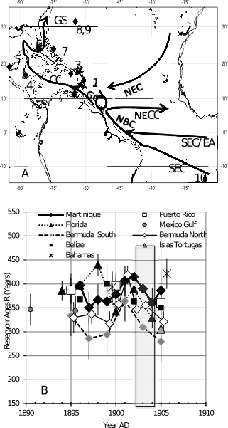
Sea surface reservoir ages (R) are reported from 14C measurements of the annual growth bands of coral Siderastrea siderea collected on the Atlantic coast off Martinique Is., in the Lesser Antilles volcanic arc. Mean values of R are similar between 1835 and 1845 during pre-anthropogenic times at 385 ± 30 years and between 1895 and 1905 at 382 ± 20 years when there was a huge eruption from the Montagne Pelée volcano in 1902-1903. They are very similar to values of R in the Caribbean Sea, Mexico Gulf and Florida Strait. Limited 14C aging of sea surface (~40 years) may be due to enhanced volcanic activity, although within the statistical variability.
Variability of R is slightly greater during 1835-1845 than during 1895- 1905. It is linked to a moderate increase of ∆14C of 5‰, strengthened by a clear increase of
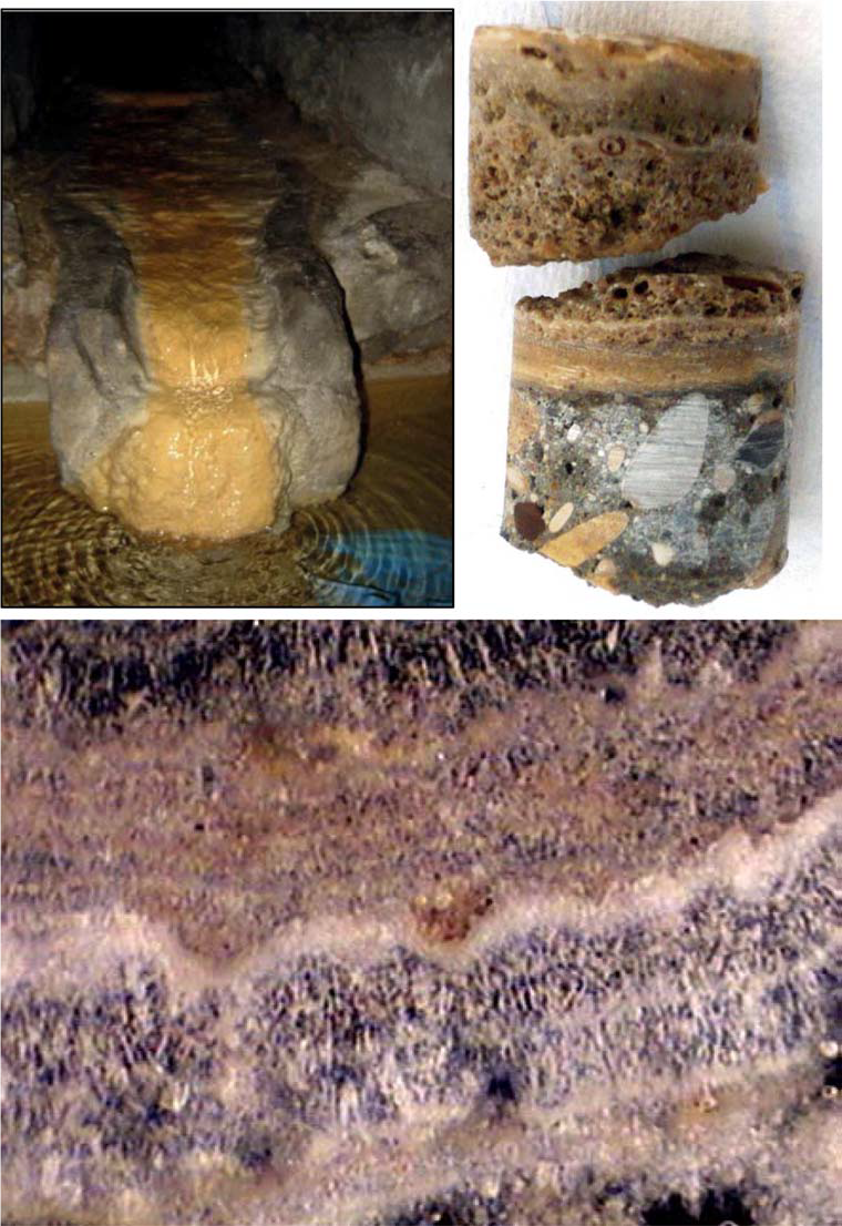
Secondary carbonate deposits (similar to speleothems) in urban undergrounds, have been recently highlighted as powerful archives for reconstruction of the historical anthropogenic imprint on the environment. The precise chronology of these secondary carbonate deposits is a key issue for the accurate time reconstruction of environmental conditions. We present three 14C data sets for urban speleothem-like deposits that developed in contrasted man made environments. The first one was sampled in an underground technical gallery of the Palace of Versailles (France), and the other two in a manhole (Saint-Martin spring) of a historical underground aqueduct in Paris (France). The comparison of these records with the bomb peak and relative chronology (laminae counting) allowed us to identify: i) fast carbon transfer from the atmosphere to the urban underground; ii) a high proportion of dead carbon and a high damping effect in relation to possible old carbon stored within urban soils and/or the influence of local fossil carbon burning. This study also shows that the lamination of these deposits is bi-annual in these highly urbanized sites.
Références : Pons-Branchu E., Bergonzini L., Tisnérat-Laborde N., Branchu P., Dumont E., Massault M., Bultez G., Malnar D., Kaltnecker E., Dumoulin JP., Noret A., Pelletier N., Roy-Barman M., 2018. 14C in urban secondary carbonate deposits: a new tool for environmental studies . Radiocarbon 60, 1269.1281. Doi:10.1017/RDC.2018.25
Projet: Aqueducs et Fontaines (Fondation des sciences du patrimoine)
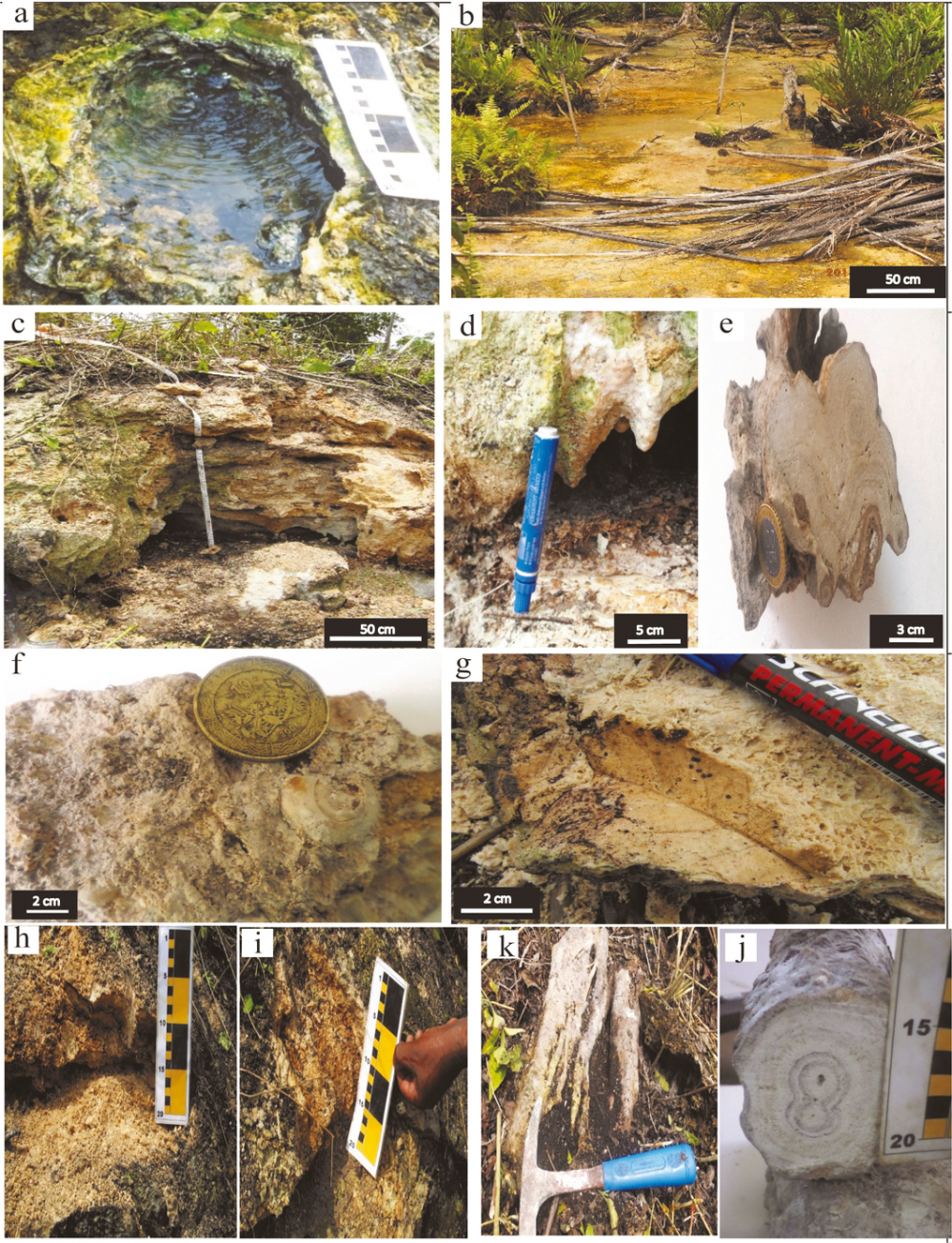
A sedimentological and geochemical study was carried out on the travertines from Bongongo and Ngol locations along the Cameroon Volcanic Line. This work seeks to ascertain: (1) the origin and typology of the studied travertine deposits, (2) the palaeo-environmental depositional model and (3) the typical characteristic of the hydrothermal system. The distribution and typology of travertine deposits were performed from natural outcrops. Oxygen and carbon stable isotope methods have been employed in the detail study of representative travertine samples from Bongongo and Ngol. The different travertine deposits along Ngol stream valley occur around waterfall/cascade, slopes and pools. At Bongongo the travertine precipitation can be linked to temporal fluctuation of carbonate mineral saturation level in rising thermal fluids and the depth of the boiling zone. The hydrothermal system of Ngol and Bongongo has been clarified using results of geochemical analyses of stable isotope, which can be applied regionally. The studied travertines are characterized by δ18O values from −8.4 to −6.4‰ V-PDB for Ngol and −5.8 to −5.9‰ V-PDB for Bongongo and δ13C values from 0.4 to 0.5‰V-PDB for Ngol and from 1.1 to 2‰V-PDB for Bongongo, in accordance with global travertine deposit environments. The values of stable carbon isotopes analyses of Bongongo and Ngol travertines are very far from the isotopic composition of magmatic carbon. Based on the geothermal environment, the high temperature parent solution (31 °C and 49°C) and stable isotope study, it can be considered that the studied travertine from Bongongo and Ngol are characteristic of the thermogenic type.
Bisse S.B., Ekomane E., Eyong J.T., Ollivier V., Douville E., Nganne M.J.M., Bitom L.D., 2018. Sedimentological and geochemical study of the Bongongo and Ngol travertines located at the Cameroon Volcanic Line. Journal of African Earth Sciences 143 201-214. Doi: 10.1016/j.jafrearsci.2018.03.028
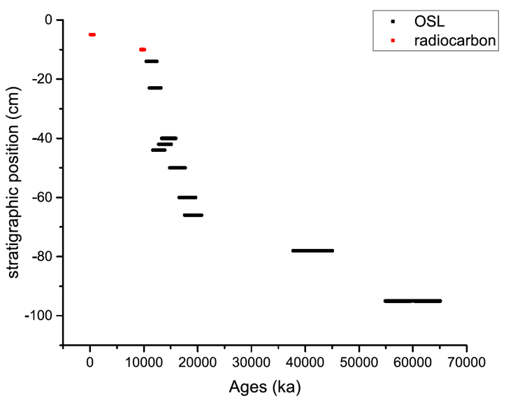
Since 2013, new excavations have focused on the northern part of the Toca da Janela da Barra do Antonião - North rockshelter, which is located on the edge of the Serra da Capivara National Park in Brazil. Ten sediment samples were dated by multigrain quartz OSL and three samples by feldspar IRSL. Multigrain OSL ages on quartz were assessed using the Central Age Model (CAM) and a Bayesian model built with the R BayLum statistics package. Ages are in good stratigraphic agreement and ages from quartz and feldspars, when available, are internally consistent. Furthermore, we produced a Bayesian model (BayLum) based on OSL ages obtained for the six sediment samples of the main stratigraphy that included stratigraphic constraints and a covariance matrix of errors. Two gaps in sedimentation were detected and can be correlated with climatic changes during the MIS 3 and during the MIS 3 to MIS 2 transition. Finally, our results provide a chronological framework for a new important Pleistocene-Holocene sequence in the region.
Référence : Lahaye C., Guérin G., Gluchy M., Hatté C., Fontugne M., Clemente-Conte I., Santos J.-C., Villagran X.S., Da Costa A., Borges C., Guidon N., Boëda E., 2019. Another site, same old song: The Pleistocene-Holocene archaeological sequence of Toca da Janela da Barra do Antonião-North, Piaui, Brazil. Quaternary Geochronology 49, 223-229. Doi: 10.1016/j.quageo.2018.03.006
Financé par projet Ministère des Affaires Européennes et Étrangères
Air enclosed in ice cores provides a unique archive for paleo-climate studies. Understanding the air enclosure process is essential for better quantifying the age of air trapped in the bubbles, correct for artifacts in elemental and isotopic composition of trapped species and estimate the smoothing effect associated with air enclosure for reconstruction of past atmospheric signal.
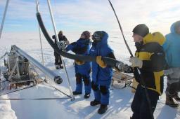
The latest deep ice core drilling project is at EastGRIP, in NorthEast Greenland, and aims to provide information of the past evolution of the North East Greenland ice Stream, along with outstanding ice quality over the Holocene Epoch, which has not been retrieved efficiently in past projects due to brittle ice issues.
As with any deep drilling project, it is necessary to characterize the air enclosure process, with a firn air campaign. Using a taylor made pumping system, air is retrieved at different depths, and analyzed.
In June 2017, and LSCE-IGE-U. Copenhagen team conducted such a firn air campaign, collecting samples for 10 laboratories across the world, from 0 to 60m depth.
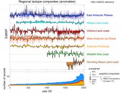
Climate trends in the Antarctic region remain poorly characterized, owing to the brevity and scarcity of direct climate observations and the large magnitude of interannual to decadal-scale climate variability. Here, within the framework of the PAGES Antarctica2k working group, we build an enlarged database of ice core water stable isotope records from Antarctica, consisting of 112 records. Our new reconstructions confirm a significant cooling trend from 0 to 1900 CE across all Antarctic regions where records extend back into the 1st millennium, with the exception of the Wilkes Land coast and Weddell Sea coast regions. Within this long-term cooling trend from 0 to 1900 CE, we find that the warmest period occurs between 300 and 1000 CE, and the coldest interval occurs from 1200 to 1900 CE. Since 1900 CE, significant warming trends are identified for the West Antarctic Ice Sheet, the Dronning Maud Land coast and the Antarctic Peninsula regions, and these trends are robust across the distribution of records that contribute to the unweighted isotopic composites and also significant in the weighted temperature reconstructions. Only for the Antarctic Peninsula is this most recent century-scale trend unusual in the context of natural variability over the last 2000 years. However, projected warming of the Antarctic continent during the 21st century may soon see significant and unusual warming develop across other parts of the Antarctic continent
As part of its ongoing project on repositories for high-activity, long-lived radioactive waste, a 2000 m deep borehole was drilled by the French Nuclear Waste Agency (ANDRA) in the layered structure of alternating aquifers and aquitards of the Eastern Paris Basin. Among the information retrieved from this borehole, the vertical distribution of chloride in porewaters showed that, in addition to vertical diffusion, lateral advection in the aquifers plays a major part in transporting chlorine away from the study area. Helium concentrations were also measured in porewaters along the borehole. Because the helium input function is different from that of chlorine, it represents an excellent alternative tracer to further constrain transport characteristics. We applied an advection–diffusion model to the helium profiles with the appropriate source term for 4He based on U–Th measured concentrations of uranium and thorium. 40Ar/36Ar data, which were available along the whole sequence, were also simulated.
Si les dynamiques de l’océan et de l’atmosphère peuvent être représentées par des modèles physiques explicites comme les GCMs, ce n’est plus le cas lorsqu’il s’agit de l’évolution à long terme des calottes de glaces ou bien du cycle du carbone, notamment en réponse aux forçages astronomiques. Afin de construire une théorie de ces variations, nous avons formalisé les principaux mécanismes sous forme d’un modèle conceptuel.
L’évolution couplée climat-carbone lors des cycles glaciaire-interglaciaire peut sans doute s’expliquer via les processus de formations d’eaux de fond Antarctiques (Paillard, 2015 ; Mariotti et al. 2016). Cependant, l’existence de cycles à 400 000 ans dans les enregistrements de 13C cycles n’est pas spécifique du Quaternaire (eg. Paillard & Donnadieu, 2014). Sur le Plio-Pléistocène, la modulation d’amplitude de l’excentricité à 2-2,4 millions d’années permet d’expliquer simplement, à travers un modèle conceptuel, non seulement l’allure des cycles du 13C, mais aussi, de façon conjointe, une modulation du carbone total sur Terre avec une première chute du CO2 atmosphérique vers 2,7 Ma BP (début du Pléistocène et des cycles à 41 ka), puis une deuxième chute vers 0.7 Ma BP (Mid-Pleistocene transition, début des cycles à 100ka).
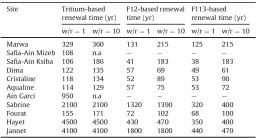
Bottled waters are increasingly popular in Tunisia. Most of them come from groundwaters, thus raising the question of the long-term availability of the mineral groundwater resources. Water collected from production springs or wells of eleven mineral waters of Tunisia among the main commercial brands were analyzed for tritium (3H), helium-3, SF6, CFCs and carbon-14. Tracer-tracer plots indicate that all of the groundwaters of our data set are a mixture of modern rainwater with older groundwater flow waters that are beyond the time-scale of the transient tracers. 14C data suggest that the age of these old waters, which constitute the main water reservoir, is of the order of radiocarbon half-life or more. Most of the studied sites have groundwater residence times in the range 50-150 years.
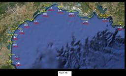
The Rhône is characterised by a heavy concentration of nuclear-based industries including nuclear power stations and nuclear sites housing civilian and military facilities. Here, we report the results of a four-year survey (2010-2013) of tritium and radiocarbon levels in a variety of matrices within the Rhône delta and along the French Mediterranean coastline. The aim of the study is to create a spatial reference framework of environmental levels of these two radionuclides, which are the most prevalent in liquid radioactive effluents from nuclear power stations. Although both tritium and radiocarbon levels in the samples analysed are very low and can only be detected using ultra-sensitive analytical techniques, they clearly show the influence of the tritium and radiocarbon discharges carried by the Rhône plume along the Mediterranean coast. The tritium content of suspended matter and sediments of the Rhône is a special case, which shows elevated tritium values not seen in other French rivers with similar nuclear facilities.
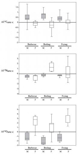
Objectives: Stable isotope data provide insight into the reconstruction of ancient human diet. However, cooking may alter the original stable isotope compositions of food due to losses and modifications of biochemical and water components.
Methods: To address this issue, carbon, nitrogen and oxygen isotope ratios were measured on meat aliquots sampled from various animals such as pork, beef, duck and chicken, and also from the flesh of fishes such as salmon, European seabass, European pilchard, sole, gilt-head bream, and tuna. For each specimen, three pieces were cooked according to the three most commonly-known cooking practices: boiling, frying and roasting on a barbecue.
Results: Our data show that cooking produced isotopic shifts up to 1.8‰, 3.5‰ and 5.2‰ for δ13C, δ15N and δ18O values, respectively. Such variations between raw and cooked food are much greater than previously estimated in the literature; they are more sensitive to the type of food rather than to the cooking process itself, except in the case of boiling.
Conclusions: Reconstructions of paleodietary may thus suffer slight bias in cases of populations with undiversified diets that are restrained towards a specific raw or cooked product, or using a specific cooking mode. In cases of oxygen isotope compositions from skeletal remains (bones, teeth), they not only constitute a valuable proxy for reconstructing past climatic conditions, but they could also be used to improve our knowledge of past human diet.
Authors : P. Jean-Baptiste, E. Fourré, E. Gaubi, B. Minster, L. Aquilina, T. Labasque, J.L. Michelot, M. Massault, A. Ben Mamou
Applied Geochemistry, 85, 10-18 (2017)
We present a comprehensive account of tritium and 3He in the Mediterranean Sea since the appearance of the tritium generated by the atmospheric nuclear-weapon testing in the 1950s and early 1960s, based on essentially all available observations. Tritium in surface waters rose to 20 - 30 TU in 1964 (TU = 1018 * [3H]/[H]), a factor of about 100 above the natural level, and thereafter declined 30-fold up to 2011. The decline was largely due to radioactive tritium decay, which produced significant amounts of its stable daughter 3He. We present the scheme by which we separate the tritiugenic part of 3He and the part due to release from the sea floor (terrigenic part). We show that the tritiugenic component can be quantified throughout the Mediterranean waters, typically to a ± 0.15 TU equivalent, mostly because the terrigenic part is low in 3He. This fact makes the Mediterranean unique in offering a potential for the use of tritiugenic 3He as a tracer. The transient distributions of the two tracers are illustrated by a number of sections spanning the entire sea and relevant features of their distributions are noted. By 2011, the 3He concentrations in the top few hundred meters had become low, in response to the decreasing tritium concentrations combined with a flushing out by the general westward drift of these waters
Cette étude montre que si le CO2 atmosphérique continue d'augmenter, les différences entre été et hiver des extrêmes d'acidité des océans doubleront d'ici à la fin du siècle. Elle met donc en doute l'idée que les régions présentant actuellement une forte variabilité entre saisons pourraient offrir à leurs organismes marins une certaine résistance aux changements des conditions moyennes plus lents mais progressifs, tels que ceux provoqués par l'acidification des océans.
L’augmentation de la différence d’acidité entre été et hiver devrait se produire dans toutes les régions océaniques (Figure 1, en haut). Dans les régions tropicales et subtropicales, l’impact de cet accroissement sur les organismes risque alors de s'aggraver en été lorsque l'acidité est la plus élevée et de s'améliorer en hiver lorsque l'acidité est la plus faible.
Les projections futures de ces extrêmes saisonniers proviennent de neuf modèles CMIP5. Les études antérieures des changements futurs de l'acidification des océans ont principalement porté sur les conditions moyennes annuelles et ne tiennent pas compte des changements des extrêmes d'hiver et d'été.
L’étude a aussi comparé les projections futures des variations saisonnières de l’acidité aux changements potentiels de la variabilité quotidienne en utilisant des mesures continues de pH recueillies sur deux sites voisins dans la baie de Naples. Un site a servi de référence actuelle, tandis que l'autre montrait les niveaux d'acidité et de CO2 attendus pour la fin du siècle, étant affectés par le CO2 volcanique bouillonnant naturellement depuis le fond marin. La différence jour-nuit de l'acidité au site perturbé était d’environ le double de celle du site de référence, ce qui concorde avec les résultats des projections du modèle pour l'amplification saisonnière.
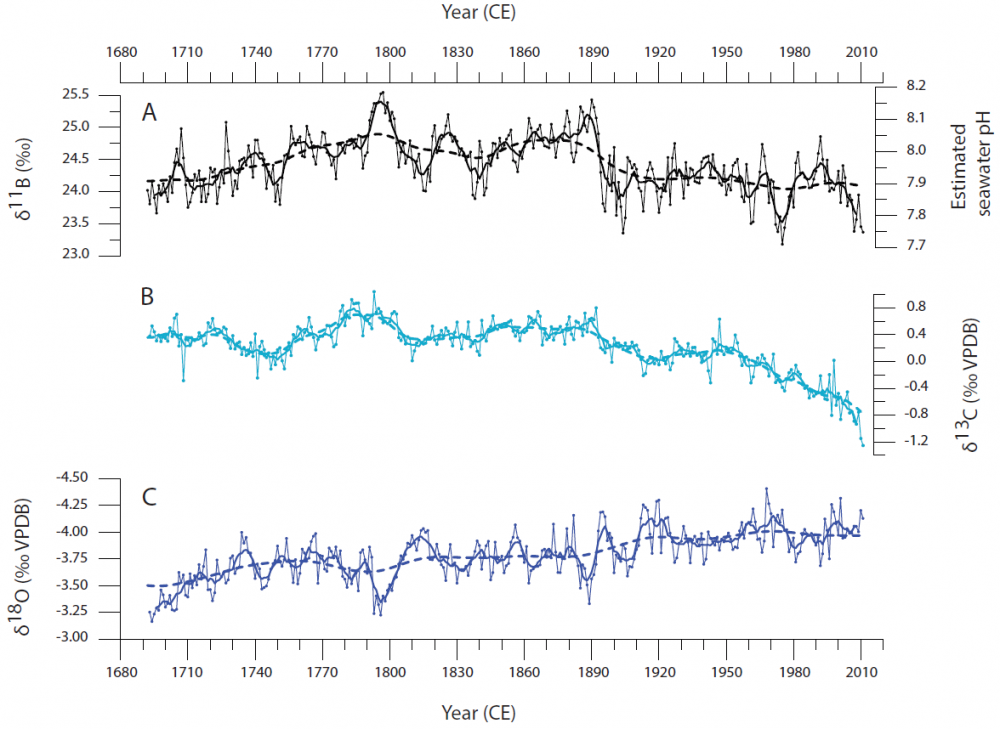
Increasing atmospheric CO2 from man-made climate change is reducing surface ocean pH. Due to limited instrumental measurements and historical pH records in the world’s oceans, seawater pH variability at the decadal- and centennial scale remain largely unknown and require documentation. Here we present evidence of striking secular trends of decreasing pH since the late 19th century with pronounced interannual to decadal-interdecadal pH variability in the South Pacific Ocean from 1689 to 2011 CE.
High-amplitude oceanic pH changes, likely related to atmospheric CO2 uptake and seawater dissolved inorganic carbon fluctuations, reveal a coupled relationship to sea surface temperature variations and highlight the marked influence of El Niño/Southern Oscillation and Interdecadal Pacific Oscillation. We suggest changing surface winds strength and zonal advection processes as the main drivers responsible for regional pH variability up to 1881 CE, followed by the prominent role of anthropogenic CO2 in accelerating the process of ocean acidification.
Référence : Wu H.C., Dissard D., Douville E., Blamart D., Bordier L., Tribollet A., Le Cornec F., Pons-Branchu E., Dapoigny A., and Lazareth C., 2018. Surface ocean pH variations since 1689 CE and recent ocean acidification in the tropical south Pacific. Nature communications 9, 2543. Doi: 10.1038/s41467-018-04922-1
Projects: AO-IPSL-2014; ANR-Labex L-IPSL (Henry Wu – Post-doc 24 months) & ANR CARBORIC
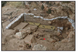
Abstract To date, the earliest modern human fossils found outside of Africa are dated to around 90,000 to 120,000 years ago at the Levantine sites of Skhul and Qafzeh. A maxilla and associated dentition recently discovered at Misliya Cave, Israel, was dated to 177,000 to 194,000 years ago, suggesting that members of the Homo sapiens clade left Africa earlier than previously thought.This finding changes our view on modern human dispersal and is consistent with recent genetic studies, which have posited the possibility of an earlier dispersal of Homo sapiens around 220,000 years ago.The Misliya maxilla is associated with full-fledged Levallois technology in the Levant, suggesting that the emergence of this technology is linked to the appearance of Homo sapiens in the region, as has been documented in Africa.
Référence : Hershkovitz et al. including Valladas., 2018. The earliest modern humans outside Africa. Science 359, 456–459. Doi: 10.1126/science.aap8369
![]() PHoCEA DRF - Tous droits réservés - Mentions légales - Protection des données personnelles - Dernière mise à jour : 25-04-2024
PHoCEA DRF - Tous droits réservés - Mentions légales - Protection des données personnelles - Dernière mise à jour : 25-04-2024
